









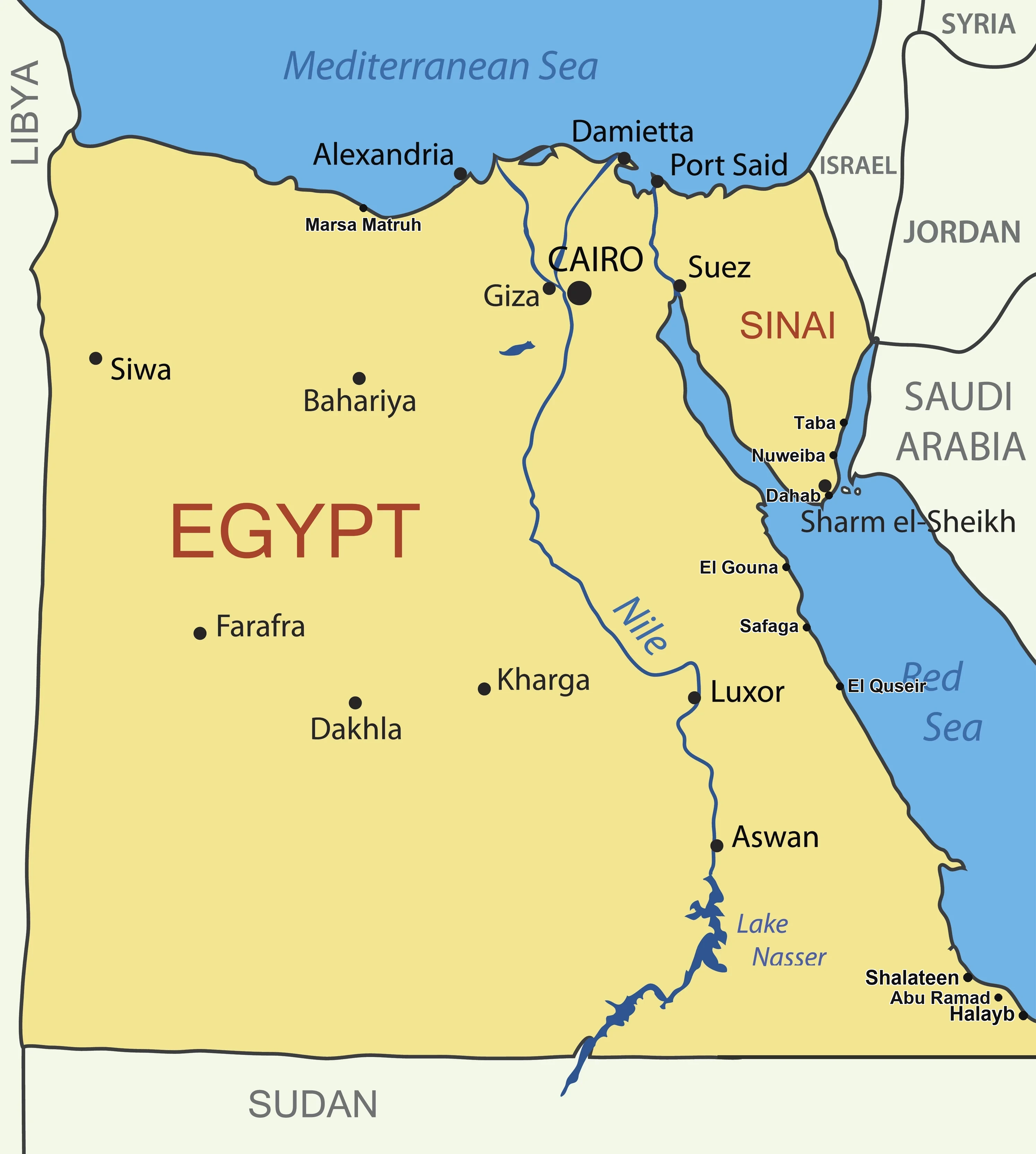
Map of Egypt: Regions at a Glance
Egypt covers 1,001,450 km² (386,662 sq mi), the 30th-largest country in the world. It stretches roughly 1,024 km north-to-south and 1,240 km east-to-west, with around 2,900 km of Mediterranean and Red Sea coastline combined. Most of the population — and almost every tourist attraction — is concentrated along the Nile River valley or on the two coasts.
Distances on the Egypt Map
Before you plan a multi-city trip, it helps to know how far apart things really are. These are the most common driving/flying distances between the cities you see on our interactive map of Egypt:
| From → To | Distance | Typical travel |
|---|---|---|
| Cairo → Giza Pyramids | ~18 km | 30–45 min by car |
| Cairo → Alexandria | ~220 km | 2.5 h by car / 2 h train |
| Cairo → Luxor | ~650 km | 1 h flight / 10 h train |
| Cairo → Hurghada | ~500 km | 1 h flight / 6 h bus |
| Cairo → Sharm El Sheikh | ~500 km | 1 h flight / 7 h bus |
| Luxor → Aswan | ~220 km | 3 h by car / Nile cruise |
| Aswan → Abu Simbel | ~280 km | 3 h by car / 45 min flight |
| Hurghada → Marsa Alam | ~270 km | 3 h by car |
| Sharm El Sheikh → Dahab | ~85 km | 1 h 15 min by car |
Egypt is a big country — more than one million square kilometres — and each of its regions has a very different character. Before you start tapping markers on the interactive map above, it helps to know how the country is split up. These are the six tourist regions every visitor should know.
- Cairo & Giza — the capital region on the Nile, home to the Pyramids of Giza, the Sphinx, the Egyptian Museum and Khan el-Khalili bazaar.
- Nile Delta & Mediterranean Coast — the green triangle north of Cairo, ending at Alexandria, Rosetta and Damietta on the Mediterranean.
- Upper Egypt (Luxor & Aswan) — the open-air museum of ancient Egypt. Karnak, Luxor Temple, the Valley of the Kings, Hatshepsut, Philae and Abu Simbel are all here.
- Red Sea Riviera (Hurghada & Marsa Alam) — the mainland Red Sea coast, famous for coral reefs, snorkelling, diving and resort towns like El Gouna, Soma Bay and Port Ghalib.
- Sinai Peninsula (Sharm El Sheikh & Dahab) — the triangle east of the Suez Canal with Mount Sinai, St. Catherine's Monastery, Ras Mohammed National Park and the Blue Hole dive site.
- Western Desert & Oases — the vast desert west of the Nile with Siwa, Bahariya, Farafra and the White Desert — best visited on a 4x4 safari.
Top Cities on the Egypt Map
Most travellers to Egypt visit two or three of the following cities on a single trip. Each one has its own guide on Egyptra — tap through for things to do, tours and booking tips.
Cairo & Giza (red markers)
Egypt's capital sits on the Nile where the river splits into the delta. This is where you come for the Pyramids of Giza, the Sphinx, the Grand Egyptian Museum, the old Egyptian Museum in Tahrir, Islamic Cairo, Coptic Cairo and the Khan el-Khalili bazaar. Allow at least two full days — browse curated Cairo tours for pricing and availability. See the full Cairo travel guide.
Luxor & Aswan (orange markers)
Upper Egypt holds more ancient monuments per kilometre than anywhere else on Earth. Luxor is built on top of ancient Thebes and gives you the Karnak Temple, Luxor Temple, the Valley of the Kings, the Temple of Hatshepsut and the Colossi of Memnon. Aswan, four hours south, is the jumping-off point for Abu Simbel and Nile cruises. Plan at least three days — see the full Luxor travel guide.
Hurghada & Marsa Alam (blue markers)
The mainland Red Sea coast is Egypt's main beach and diving region. Hurghada is the largest resort town — a good base for boat tours, snorkelling trips, Orange Bay, Giftun Island and day trips inland to the Luxor day tour or Cairo. Check the Hurghada weather before you travel, browse the full list of Hurghada excursions, and read the complete Hurghada guide for neighbourhoods, hotels and practical tips. Further south, Marsa Alam has quieter house reefs, dugong spotting and the famous Dolphin House.
Sharm El Sheikh & Dahab (purple markers)
Sharm El Sheikh is the Red Sea's other major hub, on the southern tip of the Sinai Peninsula. It's closer to Ras Mohammed National Park and the Blue Hole, and offers direct access to Mount Sinai, St. Catherine's Monastery and the Coloured Canyon. Expect Bedouin desert safaris, diving and an old market packed with cafés and shops. Check the year-round Sharm el-Sheikh weather, browse all Sharm excursions, or read the full Sharm el-Sheikh guide.
Alexandria & the Mediterranean
Alexandria is the second city of Egypt and the only Mediterranean stop most itineraries include. Highlights are the Bibliotheca Alexandrina, Qaitbay Citadel (built on the site of the ancient Lighthouse of Alexandria), the Roman Amphitheatre and the Catacombs of Kom El Shoqafa.
Ancient Egypt Map: Pyramids, Temples & Tombs
The ancient Egyptians built almost everything along a narrow green strip either side of the Nile, because that was where life was possible. Reading the map from north to south, these are the sites to know:
- Giza Plateau (outskirts of Cairo) — the Great Pyramid of Khufu, the pyramids of Khafre and Menkaure, and the Great Sphinx.
- Saqqara & Dahshur — older pyramid fields including the Step Pyramid of Djoser, the Bent Pyramid and the Red Pyramid.
- Tell el-Amarna — Akhenaten's short-lived capital in Middle Egypt.
- Abydos & Dendera — two of Egypt's best-preserved temples, between Luxor and Sohag.
- Luxor (ancient Thebes) — Karnak, Luxor Temple, the Valley of the Kings, the Valley of the Queens, Deir el-Bahri (Hatshepsut) and the Ramesseum.
- Aswan — the Philae Temple of Isis, the Unfinished Obelisk, the Nubian Museum and the High Dam.
- Abu Simbel — Ramses II's two rock-cut temples, relocated above the waters of Lake Nasser.
All of these sites appear with grey markers on the interactive map above — tap any of them for photos and opening information.
Where is Egypt on the World Map?
Egypt is in the northeast corner of Africa, at approximately 26.8° N, 30.8° E. It is bordered by the Mediterranean Sea to the north, the Red Sea to the east, Libya to the west, and Sudan to the south. The Sinai Peninsula, east of the Suez Canal, lies in western Asia, which makes Egypt a transcontinental country linking two continents.
From top to bottom, Egypt stretches about 1,024 km (636 mi) — roughly the distance from London to Nice. East to west it measures around 1,240 km (771 mi). The total area is 1,001,450 km² (386,662 sq mi), making Egypt the 30th largest country in the world and the third most populous in Africa.
Egypt Travel Tips: How to Use This Map for Your Trip
The interactive map above is designed to help you plan the shape of your Egypt trip in a single glance:
- Pick your base. Most visitors split time between one "history" base (Cairo or Luxor) and one "beach" base (Hurghada, Marsa Alam or Sharm El Sheikh). Look at the distance between markers before you book flights.
- Tap any marker to see a short description and open the detailed page for that destination — from there you can check prices, reviews and availability.
- Use the category colours (red = Cairo, orange = Luxor/Aswan, blue = Hurghada, purple = Sharm, teal = Marsa Alam, grey = ancient sites) to plan a themed trip: all ancient sites, all beach, or a mix.
- Combine near-neighbours. Hurghada and Luxor are only a 4-hour drive apart, so a Luxor day trip from Hurghada is one of the most popular add-ons. Sharm and Cairo are 70 minutes apart by direct flight.
- Plan around the heat. October–April is peak season across all of Egypt. In May–September, focus on the Red Sea (where the breeze helps) and avoid midday at desert sites.
Need help turning the map into a real itinerary? Read the full Egypt travel guide or contact our team for a custom plan.